Posted by Guest Post
Fort Ord Warhorse Cycling Tour
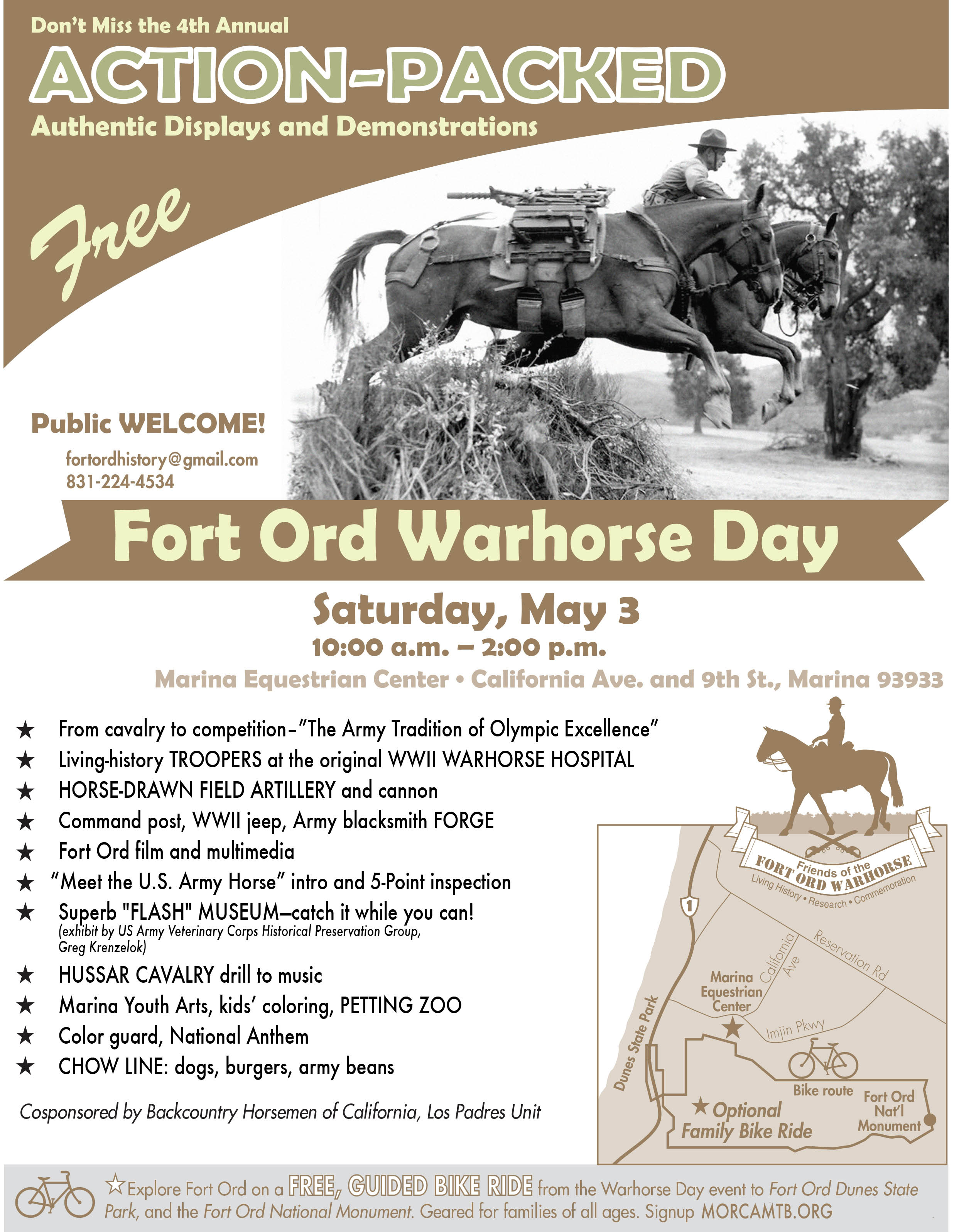
Have you missed the Fort Ord Warhorse Day Rides that have been held in many recent years, in spring? Scroll down for directions and do it with friends anytime.
Contact Margaret Davis to learn more: http://www.fortordwarhorse.org/events.html
* * * * *
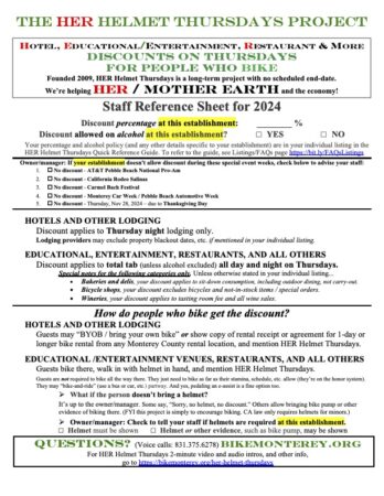
Geared for families with members of all ages, a free, guided bike ride is part of the fun on May 3, 2014! Bike from the Fort Ord Warhorse Day event to the Fort Ord Dunes State Park and Fort Ord National Monument.
Check out more details on the poster, and note the request to sign up in advance for the bike ride. Sign up at morcamtb.org.
- Looking for the May 10th coastal ride launching from Fort Ord Dunes State Park parking lot? Click here.
- Looking for more Bike Month activities? See http://bit.ly/BikeMonth2014
A description of the route for the
May 4, 2014 guided bike ride is
provided below the poster.
Below was previously published for 2013.
11-Mile Fort Ord Bike Ride – Friends of the Fort Ord Warhorse
Guest post by Margaret Davis
Here you go, instructions for the 11-mile bike ride to Fort Ord National Monument and Fort Ord Dunes State Park, as enjoyed on Fort Ord Warhorse Day and for everyday use.
Road bikers should be aware that there are some pockets of sand on the Jerry Smith Corridor, but they’re not extensive. The rest of the way is mostly paved. Terrain is hilly, riders need to be in reasonable shape. Layered clothes and sunscreen a must. Comanche’s Grave is the perfect place for a water break, sitting on the 11th Cavalry watering troughs and enjoying the view. At a leisurely pace, plan for two hours.
Ride starts at Marina Equestrian Center, corner of 5th Ave and 9th St in Marina. From Hwy 1, Exit Imjin Pkwy, R on California, park at corner of 9th St.
1. From the Marina Equestrian Center head south on 5th Ave to Inter-Garrison Rd.
2. Turn left (East) on Inter-Garrison Road and head toward the Jerry Smith Corridor.
3. Turn right on the Jerry Smith Corridor and head South toward Watkins Gate Rd.
4. Cross Watkins Gate Rd and go into the Fort Ord National Monument (Trail 52)
5. Turn right (Southwest) on Trail 14 toward Trail 19. If you see the 11th Cavalry watering troughs on your left, you’ve gone a tiny bit too far.
6. Turn Left (South) on Trail 19 and stop immediately at Commanche’s Grave (linger while you appreciate the history and beauty around you. Troughs are good to sit on while having some water.)
7. Head back to Trail 14 and go left (Southwest) toward Henneken’s Ranch Rd.
8. Turn right (Northwest) on Henneken’s Ranch Rd and head to the intersection of Watkin’s Gate Rd and Gigling Rd.
9. Turn left (West) on Gigling Rd and head toward 7th Ave.
10. Turn right (North) on 7th Ave toward Inter-Garrison Rd.
11. Turn left (West) on Inter-Garrison Rd toward 2nd Ave.
12. Turn left (South) on the old bike path next to 2nd Ave and head toward Divarty St.
13. Turn right (West) on Divarty St (careful crossing the street) and head toward 1st Ave/Hwy 1.
14. Turn right (North) on 1st Ave and follow the signs to Fort Ord Dunes State Park, crossing Hwy 1 over the 8th Street bridge.
15. Ride out on the Overlook at Fort Ord Dunes State park where Stilwell Hall Soldiers Club used to be. Enjoy the view and the bit of history.
16.* Head back out and return to 1st Ave the way you came going back, over Hwy 1 and the 8th Street bridge. See note below.
17. Turn left on DIvarty St and climb the hill to 2nd Ave.
18. Cross 2nd Ave and turn left (North) following the bike path that parallels 2nd Ave toward 8th St and Water City Roller Hockey.
19. Look for the Monterey Institute for Research in Astronomy on your right and then cross 2nd Ave at 8th St. Look for Water City Roller Hockey on your right (North). Stop in for a snack and to admire the beautiful architecture of the ceiling and possibly watch a bit of skating.
20. Leave Water City Roller Hockey and cross 2nd Ave and turn left (North) on the bike path.
21. Follow 2nd Avenue North to Imjin Parkway.
22. Turn right (East) on Imjin Parkway and follow the bike path to 4th Ave.
23. Turn right (South) on 4th Ave toward 5th Ave.
24. Turn left (East) on 5th Ave and follow it around to return to the Marina Equestrian Center.
* As an alternative to direction #16, you could stay on the beach side after visiting Stilwell Hall, going south on Beach Range Road and returning to the CSUMB side by going under Hwy 1 at the Divarty tunnel.

* * * * *
Thanks to Margaret Davis of Friends of the Fort Ord Warhorse for graciously providing these written directions. You may have read Bicycling Monterey’s announcement about this ride in the April-May 2013 Monterey County Bike Community Calendar listings.The ride was part of the 3rd Annual Fort Ord Warhorse Day (2013) festivities.
You may also view highlights of the ride in a 7-minute, 27-second video “Warhorse Day Bike Ride Fort Ord 2013” by Lynn Moimboissee, which includes directional tips. Click here to go to the Carmel-by-the-Sea blog where the video is posted, then scroll to the end.
Thanks also to Henrietta Stern of Monterey Off Road Cycling Association for bringing these tips, and the video, to our attention via MORCA’s Google group news.
* * * * *
Related posts on this site
4th Annual Intergenerational Ride for Bike Month (2015)
3rd Annual Intergenerational Ride for Bike Month (2014)
2nd Annual Intergenerational Ride for Bike Week (2013)
First Intergenerational Ride for Bike Week (2012): Tales from the Day
This post was published on 9 June 2013. One or more changes last made to this post on 19 February 2018.


")


")


")
")


")